No higher resolution available.
EnglandCumberlandTrad.png (200 × 250 pixels, file size: 28 KB, MIME type: image/png)

|
This map image could be re-created using vector graphics as an SVG file. This has several advantages; see Commons:Media for cleanup for more information. If an SVG form of this image is available, please upload it and afterwards replace this template with
{{vector version available|new image name}}.
It is recommended to name the SVG file “EnglandCumberlandTrad.svg”—then the template Vector version available (or Vva) does not need the new image name parameter. |
Summary
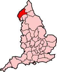
Cumberland on the map of traditional counties of England.
Moved from the English Wikipedia: http://en.wikipedia.org/wiki/Image:EnglandCumberlandTrad.png Uploaded by w:User:Morwen
Licensing
| This file is licensed under the Creative Commons Attribution-Share Alike 3.0 Unported license. Subject to disclaimers. | ||
| ||
| This licensing tag was added to this file as part of the GFDL licensing update. |

|
Permission is granted to copy, distribute and/or modify this document under the terms of the GNU Free Documentation License, Version 1.2 or any later version published by the Free Software Foundation; with no Invariant Sections, no Front-Cover Texts, and no Back-Cover Texts. A copy of the license is included in the section entitled GNU Free Documentation License. Subject to disclaimers. |
File history
Click on a date/time to view the file as it appeared at that time.
| Date/Time | Thumbnail | Dimensions | User | Comment | |
|---|---|---|---|---|---|
| current | 17:11, 25 February 2007 | | 200 × 250 (28 KB) | wikimediacommons>Powerek38 | Cumberland on the map of traditional counties of England. Moved from the English Wikipedia: http://en.wikipedia.org/wiki/Image:EnglandCumberlandTrad.png |
File usage
There are no pages that use this file.
Global file usage
The following other wikis use this file:
- Usage on miraheze.org
