Size of this preview: 748 × 600 pixels. Other resolutions: 299 × 240 pixels | 599 × 480 pixels | 1,000 × 802 pixels.
Original file (1,000 × 802 pixels, file size: 201 KB, MIME type: image/jpeg)
Summary
| Description |
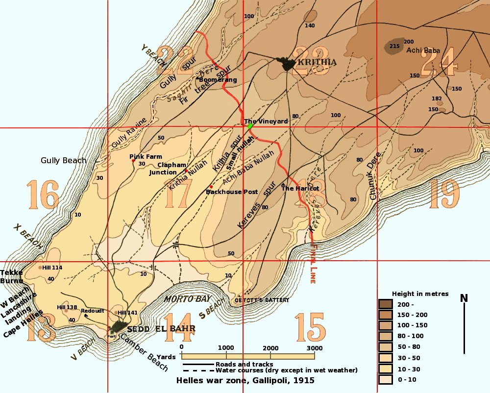
Map of the Helles war zone of Gallipoli, 1915.
|
| Date | |
| Source | Own work, based on map in "Gallipoli Diary" Volume I, General Sir Ian Hamilton, published by George H Doran Company, New York, 1920; maps in "The 42nd (East Lancashire) Division 1914-1918", Frederick P Gibbon, Country Life, London, 1920; maps in "History of the Royal Regiment of Artillery. The Forgotten Fronts and the Home Base, 1914-18", General Sir Martin Farndale, published by The Royal Artillery Association, 1988. |
| Author | Rcbutcher |
Licensing
| This work has been released into the public domain by its author, Rcbutcher at English Wikipedia. This applies worldwide. In some countries this may not be legally possible; if so: Rcbutcher grants anyone the right to use this work for any purpose, without any conditions, unless such conditions are required by law. |
File history
Click on a date/time to view the file as it appeared at that time.
| Date/Time | Thumbnail | Dimensions | User | Comment | |
|---|---|---|---|---|---|
| current | 05:30, 28 May 2008 | | 1,000 × 802 (201 KB) | wikimediacommons>Rcbutcher | e3nhanced original image optimised for screen set to gamma = 1.0 |
File usage
The following 2 pages use this file:
Global file usage
The following other wikis use this file:
- Usage on librepedia.miraheze.org
