Content added Content deleted
thegreatwar>Borderman (multiple 1915 events added) |
(increased image size, stub added) |
||
| (4 intermediate revisions by the same user not shown) | |||
| Line 1: | Line 1: | ||
[[File:Dardanelles landsat.jpg|thumb| |
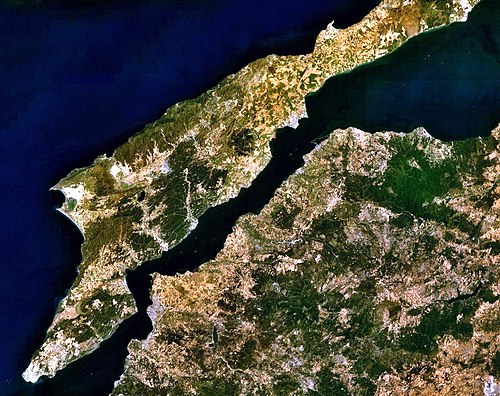
[[File:Dardanelles landsat.jpg|thumb|500px|Dardanelles and Gallipoli Peninsula]] |
||
The '''Dardanelles''' is a narrow strait in the northwestern area of |
The '''Dardanelles''' is a narrow strait in the northwestern area of Turkey that connects the Aegean Sea with that of the Sea of Marmara. Roughly 38 Miles (61 kilometers) long, it varies in width from 3/4 miles at its narrowest to 4 miles at its widest (1.2 to 6 kilometers). The strait connects the Black Sea to the Mediterranean Sea; in addition to this it separates mainland Europe (on the western side of the Gallipoli peninsula) to that of mainland Asia (on the eastern side). |
||
==Chronological events== |
|||
'''Chronological''' events that took place in the '''{{PAGENAME}}'''.<ref>{{Gleichen-123}}</ref> |
|||
*'''1914''' |
|||
**[[1 October]] – Closed by the Turks. |
|||
**[[3 November]] – Forts [[bombarded]] by the [[Allies]]. |
|||
*'''1915''' |
|||
**[[19 February|19]], [[20 February|20]] & [[25 February]] – Outer forts [[bombarded]] by warships. |
|||
**[[25 February|25]]-[[26 February]] – Anglo-French squadron destroys four entrance forts. |
|||
**[[2 March|2]]-[[4 March]] – After bad weather, bombardment of inner forts and Bulair. |
|||
**[[5 March|5]]-[[7 March]] – {{HMS|Queen Elizabeth}}, {{HMS|Ocean}} and {{HMS|Agamemnon}} shell Narrows forts from the Gulf of Saros. |
|||
**[[18 March]] – The big attack fails; HMS ''Ocean'', {{HMS|Irresistible}} and the French battleship ''Le Bouvet'' are sunk by mines; {{HMS|Inflexible}} and the French battleship ''Gaulois'' are damaged. |
|||
**[[20 April|20]]-[[30 April]] – [[Expeditionary Force]] (120,000 men) including six [[Division]]s under Sir Ian Hamilton and a French force under General d'Amade, lands early in April; British submarine exploits. |
|||
**[[25 April|25]]-[[26 April]] – Landing of forces at [[Cape Helles]] and [[Anzac Cove]]. See [[Gallipoli]] for events pertaining to land fighting. |
|||
**[[12 May]] – {{HMS|Goliath}} sunk by torpedo destroyer. |
|||
**[[26 May|26]]-[[27 May]] – {{HMS|Triumph}} and {{HMS|Majestic}} torpedoed. |
|||
**[[5 June]] – Optimistic view of the operations taken by [[Winston Churchill]] in his speech at Dundee. |
|||
**[[19 July]] – Number of casualties are announced: approx. 8,000 killed, 30,000 wounded and 11,000 missing. |
|||
**[[6 August]] – [[Suvla Bay]] landing takes place. |
|||
**[[16 August]] – Large number of reinforcements are refused. |
|||
**[[2 September]] – Four Turkish transports are sunk by British submarines. |
|||
**[[16 October]] – Sir Ian Hamilton is relieved by Sir Charles Monro. |
|||
**Withdrawal is being considered during the autumn. The decision to evacuate is made in November. |
|||
**[[18 December|18]]-[[20 December]] – Evacuation of Suvla Bay and Anzac Cove successful. |
|||
<!--<div class="res-img">[[File:Dardanelles fleet-2.jpg|Dardanelles Fleet between 1915 and 1916]]</div>--> |
|||
<!--{{refs}}--> |
|||
{{glossary}} |
{{glossary}} |
||
{{stub}} |
|||
| ⚫ | |||
==References/notes== |
|||
| ⚫ | |||
{{reflist}} |
|||
<noinclude> |
|||
| ⚫ | |||
[[Category:"On this day" index]] |
|||
| ⚫ | |||
[[Category:Gallipoli peninsula]] |
[[Category:Gallipoli peninsula]] |
||
</noinclude> |
|||
Latest revision as of 01:37, 13 May 2024

The Dardanelles is a narrow strait in the northwestern area of Turkey that connects the Aegean Sea with that of the Sea of Marmara. Roughly 38 Miles (61 kilometers) long, it varies in width from 3/4 miles at its narrowest to 4 miles at its widest (1.2 to 6 kilometers). The strait connects the Black Sea to the Mediterranean Sea; in addition to this it separates mainland Europe (on the western side of the Gallipoli peninsula) to that of mainland Asia (on the eastern side).
This article is a little light on content.
You can help the Lonsdale Battalion Wiki by jumping in and making some edits to expand it. See Category:Stub articles for some other pages that are also feeling left out and could do making new friends.
